GPS Fleet & Heavy Equipment Monitoring: Productive Work, Fuel Control, and Digital Waybills in One Window
Eliminate unauthorized trips, false engine hours, and fuel fraud. Track precise refill and drain volumes, verify working attachments, and coordinate vehicles alongside field crews on a single interactive map.
Accurate Fuel Accounting: Zero Lost Liters and Siphon Protection
Fuel represents up to 40% of fleet operating costs. GeoStatus cross-references digital Fuel Level Sensors (FLS), GPS mileage, and actual engine hours to eliminate false receipts and unauthorized fuel drains.
Automated Logging of Every Refill
The system accurately detects the date, timestamp, coordinates, and exact volume of fuel added. Each event is plotted on the map and timeline with a "+" marker, simplifying audits against fuel cards and receipts.
Instant Detection and Pinpointing of Fuel Drains
Any sudden fuel drop immediately triggers a "−" event marker with precise time, volume, and GPS coordinates for fast incident investigation.
Synchronized Fuel Level Timeline
A clear chart of real-time fuel levels over time. Dispatchers inspect consumption patterns across transit, idling, and heavy implement operations without manual formulas.
Manage Fleet and Field Crews on a Single Interactive Map
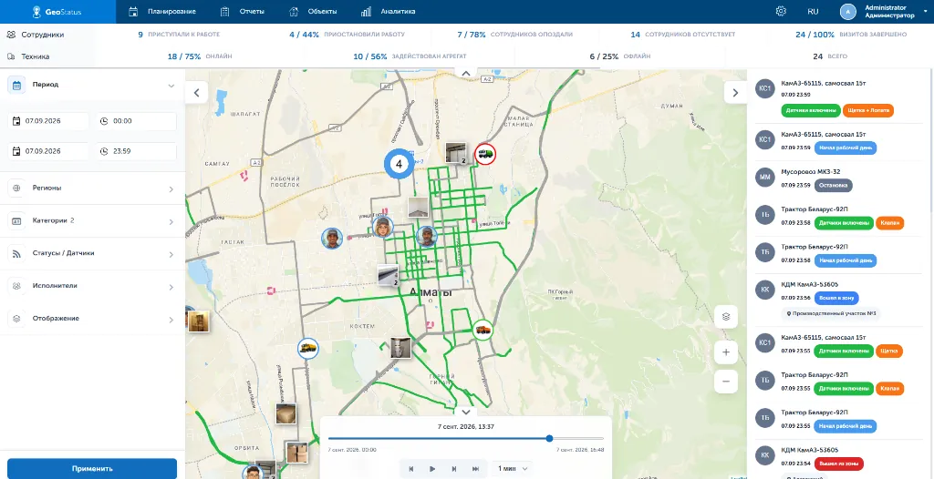
Eliminate the need to juggle disconnected tools. GeoStatus unifies vehicle GPS telematics and field workforce coordination within a single real-time dispatch dashboard.
Entire Mobile Operation on One Screen
Monitor live locations, shift statuses, and route histories of commercial fleets, heavy machinery, and mobile specialists simultaneously.
Synchronized Dispatch of Machinery and Teams
Assign tasks directly on the map mapped to specific sites and coordinates, factoring in vehicle proximity and personnel qualifications.
Rapid Onboarding Without Excess Overhead
Equip vehicles with standard GPS trackers and fuel sensors, while field crews need only standard smartphones with the GeoStatus mobile app.
Automated Geofence Monitoring: Deployment Zones and On-Site Duration Tracking
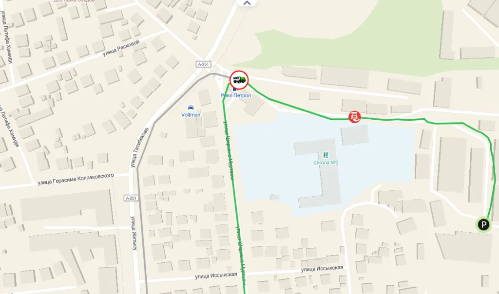
Draw boundaries for construction sites, municipal sectors, depots, warehouses, or fuel stations. The system automatically records every entrance, departure, and dwell time.
Accurate Entry, Exit, and Duration Tracking
The system automatically logs precise timestamps for arrivals and departures, calculating exact active working duration inside designated perimeters.
Deployment Zone Boundary Enforcement
If equipment leaves an assigned perimeter without authorization, dispatchers instantly see an alert badge, and managers receive real-time notifications.
Curtail Unauthorized Vehicle Use and Idling
Eliminate unauthorized parking outside designated zones, stop moonlighting trips, and gain an objective view of remote asset utilization without manual on-site inspections.
Fleet Analytics and Transparent Reports Without Manual Excel Wrangling
Make informed management decisions backed by 100% verified sensor and telemetry data, eliminating manual paperwork and human reporting bias.
Actionable Single-Window Dashboards
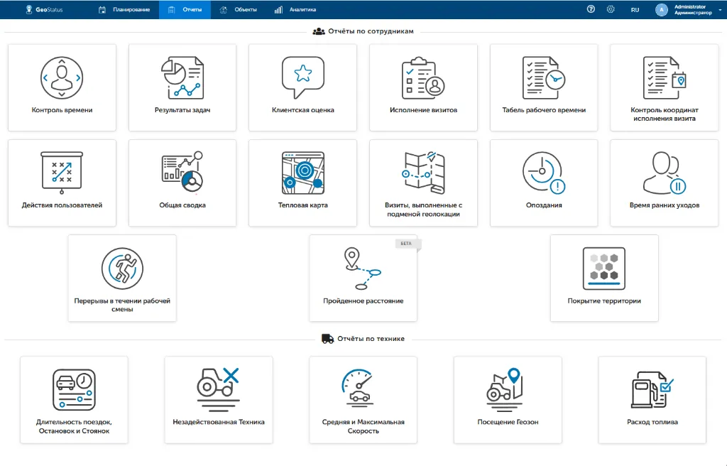
Evaluate KPIs for machinery and operators on clear visual dashboards: monitor idling, true engine hours, and speeding infractions.
Automated Timesheets and Digital Waybills
The platform automatically reconciles GPS mileage, shift durations, and fuel consumption. Generate tamper-proof reports for payroll calculation with zero human manipulation.
One-Click Export and Client Verification
Export comprehensive Excel spreadsheets to share with clients and general contractors as indisputable proof of completed service volumes and hours worked.
Custom Integrations, Bespoke Features, and On-Premise Deployment
We adapt the software to fit your operational workflows, not the other way around
Custom Integration
Seamless bi-directional data exchange with 1C, ERP, and CRM platforms via open REST API.
Platform Customization
Tailored telemetry processing algorithms for custom attachments and specialized analytical dashboards.
Private Infrastructure
Full on-premise installation on customer server clusters for 100% data sovereignty and corporate security compliance.
GeoStatus Implementation Results
Measurable economic impact and fast investment payback in the initial months of deployment
Frequently Asked Questions (FAQ)
What hardware is required to connect vehicles and personnel?
For vehicles and heavy machinery, on-board GPS trackers, digital fuel level sensors (FLS), and mechanism status sensors (tilt, vibration, hydraulic pump or broom sensors) are installed. For field staff and drivers, no dedicated devices are required — standard smartphones running the GeoStatus mobile app are all that is needed. Dispatchers and managers access the cloud interface via any desktop or tablet browser without dedicated local servers.
How does the system distinguish active attachment work from idle transit?
The platform reads telemetry signals directly from attachment sensors (sweeper brooms, watering pumps, buckets, blades, or hammers). The map renders "colored tracks": simple transit or idling is shown in gray, while sectors where implements were actively operating are highlighted in vibrant cyan or green. Dispatchers can toggle filters in a single click to hide empty transit and calculate verified completed work.
How are fuel refills recorded and how is theft prevented?
The system continuously analyzes digital fuel level sensor feeds with temperature compensation (precision error under 1%). It automatically records initial and final tank levels, logging timestamps, volume, and coordinates of refills ("+" markers) and suspected siphons ("−" markers). The synchronized consumption chart correlates sudden fuel drops with vehicle stops and route deviations.
Can vehicles and field teams be monitored inside the same application?
Yes, GeoStatus features multi-tracking out of the box. Fleet managers do not need separate software suites: commercial vehicles, heavy machinery, and mobile personnel are displayed together on a single real-time interactive map alongside shift statuses, geofences, and active tasks.
What happens if GSM connectivity or internet drops on site?
Both the mobile app and on-board GPS trackers feature offline autonomous storage. All route history, telemetry, sensor readings, and job reports are cached in local device memory. Once cellular or Wi-Fi signal is restored, all accumulated data seamlessly syncs to the cloud without data loss.
How is equipment presence tracking configured for job sites?
Dispatchers delineate polygonal geofences on the map: construction sites, municipal areas, depots, warehouses, or fuel stations. The system automatically registers arrival and departure timestamps, computes total active working duration inside the boundary, and triggers alerts if assets breach designated zones.
Are 1C/CRM integrations and On-premise deployments supported?
Yes, our open REST API enables two-way synchronization with existing corporate systems (1C, CRM, ERP). Furthermore, for enterprise organizations with strict data compliance mandates, GeoStatus is available for on-premise installation on client-owned servers with complete telemetry retention inside an isolated perimeter.